
Bill Rankin, 2013
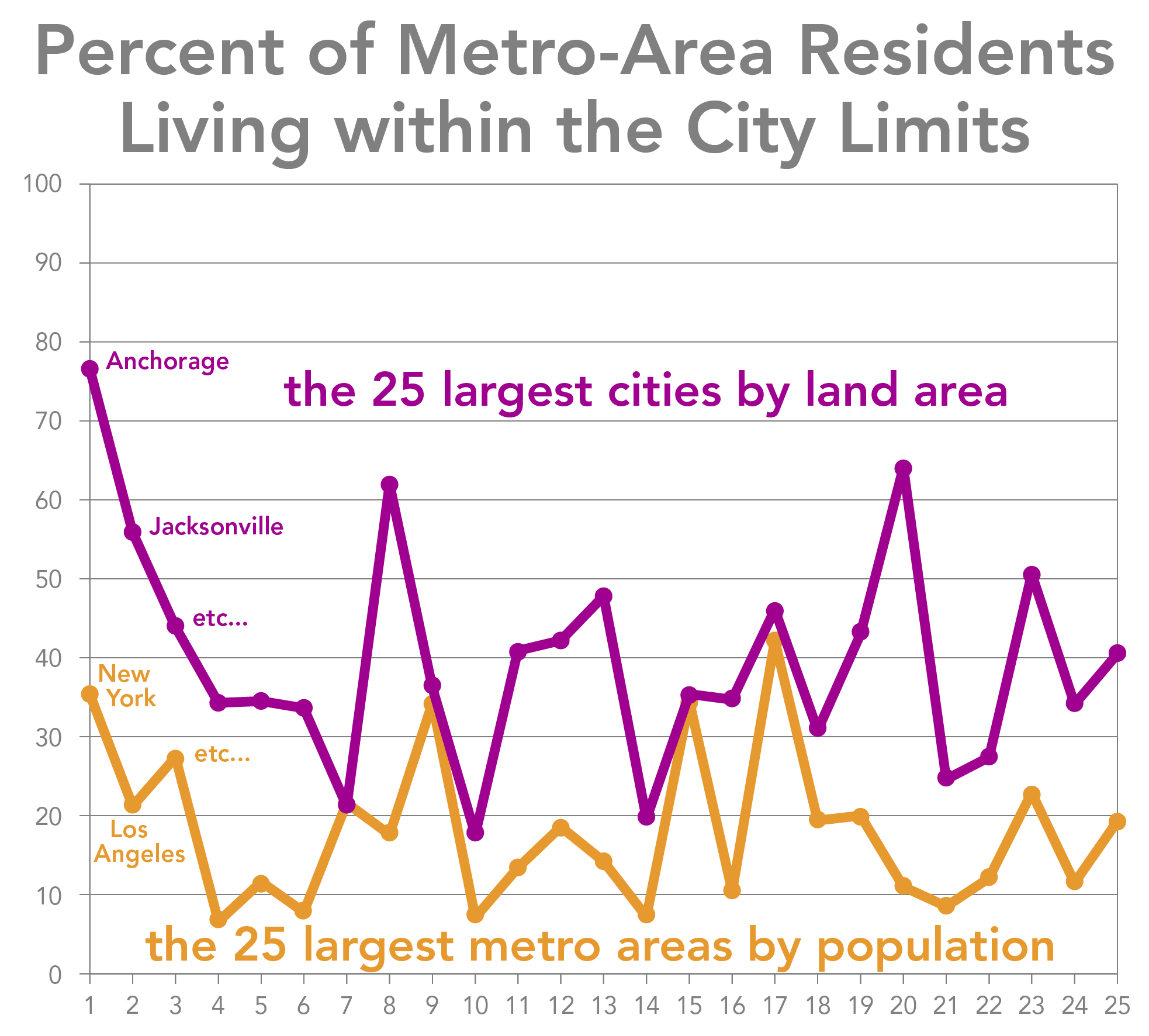
What's the biggest city in the United States — New York? Los Angeles? How about Anchorage: at 1,961 square miles, it's not just bigger than Rhode Island, but also bigger than 30 independent countries.
There are several reasons why it might make sense for a city to cast its boundaries as far into its hinterland as possible. Besides the efficiencies that come from providing services like water, power, and garbage on a metropolitan scale, expansive cities can also keep property-tax dollars from fleeing to the suburbs. In sun-belt cities like Houston or Phoenix, residents living in quiet, low-density subdivisions 20 or 30 miles from downtown are still legally part of the city.
Shown here are the twenty-five largest American cities by area; this includes all cities larger than 250 square miles. (Both land and water are counted towards a city's total size.) Except for New York City, all of these are newer, car-centric cities; only five are outside the South or Southwest. And as a group, these cities are also home to a rather high proportion of their metro-area residents — and tax dollars:
 (click to enlarge)
This graph also points to a potential contrast in identity-space between the geographically large cities of Texas, Arizona, or Southern California and geographically small cities like San Francisco, Boston, or Washington DC. The contrasts can often be striking: only 8% of the residents of the Boston metro area actually live in Boston proper, while almost two-thirds of the metro residents of San Antonio live within the city limits. Do geographically larger cities enjoy more civic-mindedness, in addition to a wider tax base? My gut says yes, but I'm afraid I don't have any actual evidence yet.
There are two paths to muncipal bigness. The traditional path is through annexation and consolidation. This is how the boroughs of New York came together in 1898 to form a metropolis, and this is the pattern we see since the mid-twentieth century with the expanding tentacles in Texas. The newer path to bigness is through the merger of a city's government with its surrounding county. This is how some of the biggest cities here got so big: Anchorage (merged 1975), Jacksonville (1968), Nashville (1963), Virginia Beach (1963), Indianapolis (1970), Louisville (2003), and Lexington (1974). New Orleans is a special case: the city has always acted as the parish [county] government, but the city did not expand to fill the parish until 1874. Yet regardless of the strategy, one common characteristic of large cities is the presence of holes — often rich enclaves that managed to resist consolidation.
Note: Consolidated city–counties with less than 250,000 people are not included here. (Namely: Sitka, Wrangell, and Juneau in Alaska; Anaconda and Butte in Montana; Suffolk and Chesapeake in Virginia; and Augusta and Cusseta in Georgia. Of these, only Suffolk, Chesapeake, and Augusta have more than 35,000 people).
Honolulu — officially the "City and County of Honolulu" — is also not included. Although it is the only official "city" in Hawaii, it has essentially the same status as the state's other four counties and provides services for the entire island of Oahu. The island with its surrounding territorial sea is 1.75 Rhode Islands; the island alone is 0.49, and urban Honolulu is only 0.06.
City boundaries current as of 2012. Population data from the 2010 U.S. Census.
